
U.S.
Fish and Wildlife Service, Division of Migratory Bird Management,
U.S. Geological Survey, Patuxent Wildlife Research Center
General Database Information
Choose
Database: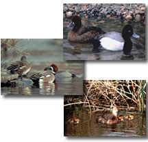
All birds
Bird Point Count Database (no longer available)
The Patuxent Wildlife Research Center (PWRC) and American Bird Conservancy (ABC) have been working together to build a repository for storing Partners in Flight point count data as well as other point count datasets. The web-based Bird Point Count Database is now ready for use by anyone conducting monitoring programs using point counts. This includes bird point count data collected using standard protocols anywhere in North America (U.S., Canada, and U.S. Territories). This database will expand the available scales for point count data analyses well beyond what is feasible with locally managed survey data.
The BBS is a long-term, large-scale, international avian monitoring program initiated in 1966 to track the status and trends of North American bird populations. The USGS Patuxent Wildlife Research Center and the Canadian Wildlife Service, National Wildlife Research Center jointly coordinate the BBS program. Each year during the height of the avian breeding season, June for most of the U.S. and Canada, participants skilled in avian identification collect bird population data along roadside survey routes. Over 4100 survey routes are located across the continental U.S. and Canada. Once analyzed, BBS data provide an index of population abundance that can be used to estimate population trends and relative abundances at various geographic scales. Trend estimates for more than 420 bird species and all raw data are currently available via the BBS web site.
Waterfowl
Since this website is no longer being maintained, if you wish to obtain data beyond 2015 for any other survey besides the WBPHS, please locate the point of contact within the 'About the Survey' webpage found on each survey's homepage.
Atlantic Flyway Breeding Waterfowl Survey (data available from 1993-2015)
Prior to 1989 no regional survey existed of waterfowl breeding populations in the northeast United States. In 1989, the Atlantic Flyway Technical Section initiated this breeding waterfowl survey in 11 northeast states ranging from New Hampshire to Virginia. The purpose of this survey was to collect breeding population abundance data that would support effective management of eastern waterfowl breeding populations. Prior to this survey (and Federal breeding waterfowl surveys initiated in 1990 in eastern Canada and Maine) eastern waterfowl populations were managed based on data collected for mid-continent populations. This survey was designed primarily to estimate population sizes of mallards (Anas platyrhynchos platyrhynchos), black ducks (Anas rubripes), wood ducks (Aix sponsa), and Canada geese (Branta canadensis), however all observed waterfowl are recorded.Atlantic Flyway Sea Duck Survey (data available from 1991-2002)
During the existance of this survey (1991-2002), existing breeding population surveys for North American waterfowl did not cover the core ranges of about half of North American sea duck species. Many species of North American sea ducks breed across vast Arctic regions that are difficult and costly to survey. Winter waterfowl surveys such as the Mid-winter Waterfowl Survey typically did not cover near shore or offshore coastal habitats used by sea ducks. The Atlantic Flyway Sea Duck Survey, was conducted by the U.S. Fish and Wildlife Service from 1991-2002 to record sea duck numbers using near shore (within 700 m of shore) habitats from Cape Breton, Nova Scotia to Jacksonville, Florida.
Mexican Mid-winter Waterfowl Survey (data available from 1947-2006)
The Mexican Mid-winter Waterfowl Survey was a continuation of the annual winter waterfowl survey which is conducted in the United States and Canada. Since the survey's inception in 1947, it was divided into 3 main surveys: the Gulf Coast, the Interior Highlands, and the Pacific Coast. Since 1985, the surveys were run every three years, 2006 being the last. In the off years, a redhead survey was flown in Laguna Madre on the Gulf Coast and a Brant goose survey on the upper (from Mexicali to Cuyutlan on the West Coast and from Bahia de Magdalena to San Quintin in the Gulfo de California) part of the Pacific Coast. The Mexican Mid-winter Waterfowl Survey provided wintering habitat conditions, waterfowl habitat utilization, waterfowl distribution patterns, and general population trends. The data obtained from this survey was used to manage Mexican duck populations and to study the effects of wetland drainage and development. It was conducted cooperatively by the U.S. Fish and Wildlife Service and Mexican officials.
Mid-Winter Waterfowl Survey (data available from 1955-2016)
Some geese and ducks are not adequately monitored during the spring and summer because they nest in areas not well covered by breeding population surveys. Abundance indices for these species are obtained from surveys on wintering areas. Most of these surveys are targeted at specific species or populations. A nationwide effort to survey all waterfowl is conducted annually in January. This, the Mid-winter Waterfowl Survey, provides information on population trends for some species, distribution on the wintering grounds, and habitat use. The Mid-Winter Waterfowl Survey is conducted cooperatively by the states and the U.S. Fish and Wildlife Service.
Waterfowl Breeding Population and Habitat Survey (data no longer available on this website, but rather through ServCat 1955-present)
The Waterfowl Breeding Population and Habitat Survey (WBPHS) is conducted annually in May and June by the U.S. Fish and Wildlife Service and the Canadian Wildlife Service. The aerial breeding surveys that evolved into the WBPHS began in 1947. The primary purpose of the WBPHS is to provide information on spring population size and trajectory for 19 North American duck species (or species groups), Canada Geese (Branta canadensis), American Coot (Fulica americana), and swans (Cygnus spp.) and to evaluate habitat conditions in Prairie-Parkland Canada, via the counting of waterfowl breeding ponds. The data are used to establish annual hunting regulations in the United States and Canada and provide a long-term time series important for researching bird-environment relationships critical to effective conservation planning for waterfowl. The survey is conducted by ground, airplane, and helicopter over a 2 million square mile area that covers the principal breeding areas of North America, and includes parts of Alaska, Canada, and the northcentral US. This survey is also referred to as the Breeding Population Survey (B-POP) or the May Survey. Data are available beginning in 1955, which is the year the survey is typically described as becoming operational, although design, methods, and coverage continued to evolve for many years. Data are not available for 2020 and only available for Alaska (strata 1-11) in 2021, due to fieldwork restrictions resulting from the COVID-19 pandemic. To obtain WBPHS data, historical documents, and population status reports, please visit ServCat Program Record # 47314 (https://ecos.fws.gov/ServCat/Reference/Profile/47314).
Waterfowl Production and Habitat Survey (data available from 1955-2003)
The Waterfowl Production and Habitat Survey, was conducted by the U.S. Fish and Wildlife Service and became operational in 1955 in the Canadian prairies (strata 26-40). In the north-central United States strata were phased in during 1958 (strata 43, 45-47), 1959 (strata 44, 48-49), and 1966 (strata 41-42). In Canada’s Northwest Territories and northern Alberta, strata (13-18,75-77) were surveyed beginning in 1966. The primary purpose of the survey was to provide information on duck production from the mid-continent breeding areas. These data were used in the past to forecast the annual fall flight of ducks. Present applications include research on habitat, climate, and waterfowl production relationships important in harvest regulation and habitat conservation.
Webless Migratory Game Birds
American Woodcock Singing-ground Survey (data available from 1968-2015)
The American Woodcock (Scolopax minor) Singing-Ground Survey is conducted by the U.S. Fish and Wildlife Service in cooperation with the Canadian Wildlife Service, state and provincial natural resource agencies, Bird Studies Canada, other U.S. and Canadian government organizations, and volunteers. The survey exploits the conspicuous courtship display of the male woodcock. The survey consists of numerous routes in the eastern half of the U.S. and Canada, which are surveyed in the spring. Counts of singing male woodcock along the routes provide an index to woodcock abundance, and are used to estimate woodcock population trends for states, provinces, management regions, and the continent. The survey is the major source of information considered in the annual setting of woodcock hunting seasons. These data can also be used to examine the effects of weather, landscape change, and other factors on woodcock population abundance.
Mourning Dove Call-count Survey (data available from 1966-2013)
The Mourning Dove (Zenaida macroura) Call-Count Survey was developed to provide an index to population size and to detect annual changes in mourning dove breeding populations in the U.S. The survey consisted of numerous routes throughout the U.S., which were surveyed in late May and early June. The resulting estimates of relative abundance and population trends once comprised the principal information used in the annual setting of mourning dove hunting seasons. These data could also be used to examine the effects of weather, landscape change, and other factors on mourning dove population abundance.
              Please note, while the U.S. Fish and Wildlife Service still maintains the server


              that houses this website, data and webpages are no longer being updated.